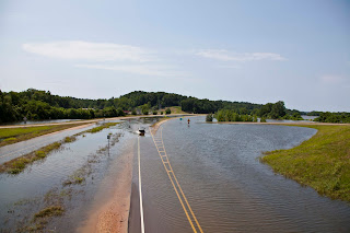
I rode up to the Redwood community Saturday morning to see how the Redwood Elementary School was faring and to also see how far over US 61 the floodwaters came. See for yourself! As always, click on the photos to enlarge them.
Notice the sleeping dog. I let him lie.
Dump trucks were running constantly while I was there. Some went up the exit ramp and then around, but some cut right through the water on the road. This is looking north.
Looking north. The Yazoo River bridge rises in the background.
On top of the exit ramp looking south.
On top of the exit ramp looking north.
The Yazoo River from atop the bridge, looking west.
The Yazoo River from atop the bridge, looking east. The guys in the boat looked like they were taking water measurements.
Northeast
West
Northwest
Northwest
North
North
Southeast
Southwest
South
The Great River Road.
Notice the sleeping dog. He found some shade.


Good to see Redwood is still dry, if not high. Looks like water as far as the eye can see though in every other direction. Thanks for the detailed pictures!
ReplyDeleteWow! I can hardly believe my eyes. These photographs give a number of clear views as to what's going on around the school and the highways around Redwood. I'm wondering if the McCarty-Dromgoole Cemetery near there is in safe territory ? A number of my relatives are there. Again, thanks for your photos.
ReplyDelete